Connects Lower CCC Trail to Raven Rock Trail. Closest access is 5 mi from the Jacob Fork parking area. The trail serves as a boundary between North Carolina gamelands and the park. Benn Knob Peak is a restricted area. Benn Knob is one of the highest...
Starts off of High Shoals Falls Loop Trail, 0.2 mi from the Jacob Fork parking area. This trail was rebuilt after the devastating Chestnut Knob wildfire of November 2016; it is well-constructed and easy to follow. The trail ascends on a moderately...
Starts at the Clear Creek Dam. Clear Creek Trail is the only trail on the western side of the park at present. This “out and back” trail starts at the Clear Creek Dam and ascends into the Clear Creek Watershed for a quiet, reflective retreat into...
Connects Lower CCC Trail to Raven Rock Trail. Closest access is 4.1 mi from the Jacob Fork parking area. This remote trail has an expansive vista of the Blue Ridge at the eastern end of the trail. It descends to Nettle Branch and then winds around...
Starts at the Shinny Creek picnic area, 0.5 mi from the Jacob Fork parking area. The trail provides access to Shinny Creek Trail, the Shinny Creek Backcountry Campsite and the Upper Falls Trail. One of the main artery trails which provides access to...
This easy, accessible trail follows the beautiful Jacob Fork River. There are many interpretive signs along the way, explaining various aspects of the geology, flora and fauna of the area. You'll also pass the amphitheater where interpretive programs...
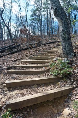
This short, but steep, and very popular trail takes hikers about a mile to High Shoals Falls. All junctions are signed and the tail is well blazed.
Starts at the Jacob Fork parking area on an old road to the right of the picnic area. (You can also...
Connects Lower CCC to Upper CCC. Closest access is 4.8 mi from the Jacob Fork parking area. This is a remote strenuous ridgeline trail that offers views west to Walker Top Mountain and the Blue Ridge Mountains. Views of the Black Mountains, Table...
Connects Upper Falls Trail to Fox Trail. Closest access is 3 mi from the Jacob Fork parking area. This moderate foot trail crosses Jacob Branch and ascends southwest to Fox Trail. Walk along the riparian area of Jacob Branch.
Starts at the Jacob Fork parking area. The trail crosses Little River and connects to the Upper CCC Trail. Horseback riders share part of this trail with hikers. Views of the Little River.
Connects Benn Knob Trail to Horseridge Trail. Closest access is 4.3 miles from the Jacob Fork parking area. The Lower CCC Trail was named for the Camp Dyer Civilian Conservation Corps (CCC). The trail follows a ridgeline that separates the Henry Fork...
Can be reached via Shinny Trail. Closest access is 1.6 mi from the Jacob Fork parking area. The trail can be combined with Chestnut Knob Trail to make a 7.7 mile loop that is one of the most popular extended hikes in the park. Leaves the Shinny Creek...
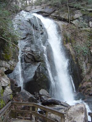
Closest access is 0.2 miles from the Cicero parking area. Raven Rock Trail crosses the park road and Jacob Fork River then ascends steeply to a paved road shared by the park and Pine Mountain Golf Resort. There is a winter view of High Shoals Falls....
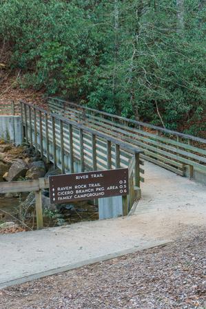
Starts at the Jacob Fork parking area and ends at the Cicero Branch parking area near the Family Campground. River Trail is an easy foot trail along Jacob Fork River. The Kid's Track Trail kiosk is located at the east end of River Trail with...
Connects Turkey Ridge Trail to Raven Rock Trail. Closest access is .3 mi from the equestrian day-use parking area. The trail crosses the Jacob Fork River and ascends to Raven Rock Trail. This narrow trail is single track for horseback riders. One of...
Connects Upper CCC Trail to Horseridge Trail. Closest access is 2.5 mi from the Jacob Fork parking area. Sawtooth Trail crosses Little River at the top of a waterfall. The trail follows a ridgeline that climbs to a view south into the Jacob Fork...
Starts at the Shinny Creek Backcountry Campsite, which is 1.2 mi from the Jacob Fork parking area. Be prepared to cross the creek twice and navigate a log foot bridge. The foot trail ascends steeply to Upper Falls Trail. Shinny Creek and Shinny Creek...
Starts at the equestrian parking lot. Main artery for the equestrian trails. The trail provides access to Saddleback Trail. Turkey Ridge Trail crosses the park road and ascends to Little River Trail. Horses and hikers share this trail.
Connects Little River Trail to Horseridge Trail. Closest access is 2.1 mi from the Jacob Fork parking area. The Upper CCC Trail was named for the Camp Dyer CCC. The trail has views north into the Little River Watershed. Horses and hikers share this...
Connects Raven Rock Trail to Lower CCC Trail. Closest access is 1.1 mi from the Jacob Fork parking area. The trail divides the park north and south. It crosses the Jacob Fork River above High Shoals Falls. Be prepared for a stream crossing. The trail...