Big Laurel Falls Trail

At A Glance


0.6 mi one-way
Difficulty Rating: 0.6 ![]()
Steepness: Hilly ![]()
Tread Condition: Moderately Rough ![]()
Trail Number: 29
Description
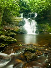
Although many sources classify this trail as Easy, I'd bump it up a notch, because it's got quite a few slippery rocky and rooty sections. Still, it's a good family trail overall and it's short. The round-trip to the falls is just over 1 mile, and the destination is a worthy one. Big Laurel Falls isn't all that big, but it's pretty, with a neat area at the base for hanging out and wading. Don't be tempted to take the scramble path to the top, though.
This trail is located in the Standing Indian Basin area. For a list of all the trails in that area, see the Standing Indian Basin trails list page.
All Photos from the Trail

Feedback
Ratings
Average Rating: (rated 0 times)
Rate It Now:

No comments yet.