Starting at the end of the road with the same name, this gravel road trail climbs to end at Sourwood Gap, where it intersects East Ridge trail and Old Mitchell Toll Road.
Climbs steeply from the parking area at the end of Suwannee Drive to the West Ridge trail. Passes through switchbacks in places; some spots require rock scrambling where the trail passes directly over outcrops. Passes through the ridge's eponymous...
Follows the ridge up and over Lookout Mountain, Boggs Bunion, Brushy Mountain and Rocky Head. Ends at Long Gap. here are a few steep sections and several good viewpoints along the trail.
The trail follows Flat Creek, and has many informative signs and nice benches on which to rest. This trail as an extension of the Nature Trail and includes "Elizabeth's Path", which was named for Elizabeth Peterson who loved to walk along this creek....
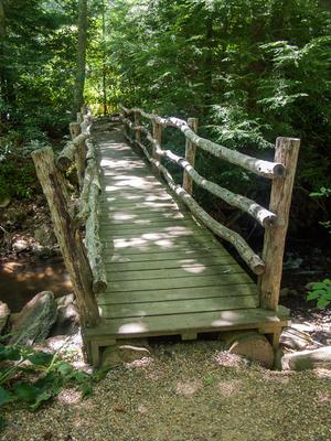
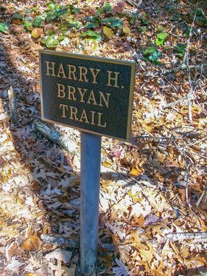
Crosses Flat Creek on a bridge and goes upstream on a steady uphill course. Past the Harry Bryan trail, the trail enters the Boggs Wilderness and climbs along an old roadbed. It crosses Flat Creek again, turns into a purpose-built singletrack trail...
A gentle up-and-down hike through the woods of Bell Forest to Flat Creek and a bridge at the Graybeard trail. Makes a nice, easy 1.8 mi loop when combined with Graybeard and/or Julia Woodward/Sanctuary trails.
Travels from the summit of Lookout Mountain to the Old Mitchell Toll Road. The Rattlesnake Mountain trail is 180 ft south and passes onto private Ridgecrest Conference Center property, which is closed to use by the general public.
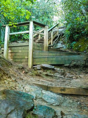
Climbs moderately through a nice cove before a few switchbacks on new stretches of trail up to the Old Trestle Road. Climbs steeply beyond Trestle Road along the ridge with stairs in places. A few stretches just before the overlook have exposed rocks...
A traverse around the foot of Big Piney Ridge. From the south trailhead at Harmony Road, this beautifully constructed trail winds along the rocky mountainside, climbs through a few switchbacks, and passes a couple of nice viewpoints and...
Follows a tourist road which once provided motorized access to the summit of Mount Mitchell from Black Mountain after the logging operations and tourist railroad had winded down. The toll road largely followed the old railroad's path, but the town of...
This is a historic logging and tourist railroad grade that once went from Black Mountain to Mount Mitchell in the early 1900's. It is called the "Trestle Road" because of the three trestles it once needed to span creeks along the route. Between...
Starts across Flat Creek from the Montreat gate; use the bridge for the Gate trail to access the trailhead. Turn right onto the gravel road once across the bridge, then turn left at the maintenance area to start the tail. The trailhead is signed.
...
The trail follows an old roadbed for most of its length. The trail ends at the gap where Old Trestle Road and Old Mitchell Toll Road split near the Lookout trail.
Tight, twisty purpose-built trail passes through laurel and rhododendron thickets, with gnarly trees including Carolina hemlock and shortleaf pine arching overhead. Has some steep ups and downs. Passes an overlook with a limited view across the...
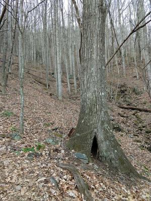
Starts at the Montreat campground next to Flat Creek and climbs the ridge west of Rocky Head (mountain) all the way to the summit. Passes the old water holding ponds (now dry) that were used for an electrical generation plant in the early 1900's. The...
Requires a long hike on the Old Mitchell Toll Road to reach the trailhead. Faint path at times. Ends on a rocky summit with spectacular views of the Asheville Watershed.
**Note**: this trail is not Montreat property, but has been purchased and...
Follows the steep gorge carved out by Little Slaty Creek. After crossing Upward Way, the trail continues upstream past the site of Montreat's old waterworks, crosses the stream on a bridge, then climbs to its terminus with the Julia Woodward trail,...
Trailhead is located on Harmony Road and ends with the junction of the West Ridge Trail at the summit of Little Piney Mountain, also known as Stomping Knob. Starts with an easy rock-hop across a small brook that runs parallel to Little Piney Branch...
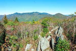
Short path near the summit of the ridge to the summit of Walker's Knob with a fantastic view south and west of Montreat, Black Mountain and the Swannanoa Valley. Has a few rocks and roots, and a small climb at the end, but it is overall very easy....
Traverses the summit of the Seven Sisters ridge from Stomping Knob to the summit of Big Slaty Mountain (False Graybeard), not far from the summit of Graybeard. Somewhat rough and steep in places. No views to speak of except through the trees in the...