Craggy Gardens Trail

At A Glance


0.9 mi one-way
Difficulty Rating: 0.9 ![]()
Steepness: Climbs Moderately ![]()
Tread Condition: Some Obstacles ![]()
Other Map ID: BRP MP 364.2
Hikes That Use This Trail: Craggy Gardens
Description
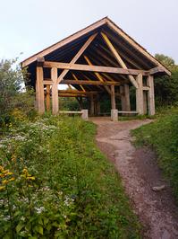
This excellent trail travels from the Craggy Gardens Visitor Center up to Craggy Flats and Craggy Knob, then down to the Craggy Gardens Picnic Area. You will first reach the intersection with the Mountains to Sea and Douglas Falls trails. From here on, the path is shared with the Mountains to Sea Trail. If you were to turn left, a strenuous, rough descent would take you to the spectacular 70 foot Douglas Falls. There is a much easier way to the falls - but which requires a lot of driving on gravel roads! This moderately steep, rocky, sometimes wet trail travels first through a northern hardwood forest and then through a Southern Appalachain "heath bald" of mostly Catawba Rhododendrons. You will reach the old trail shelter - built out of large chestnut logs - where the trail splits. Turn left to head into the Flats, where blueberry pickin' in late August and early September abounds. This spur leads shortly to a great overlook of the North Fork Reservior and Graybeard Mountain. Continuing past the trail shelter, you descend moderately through more northern hardwoods to the Craggy Gardens Picnic Area after 0.9 miles. You can start the hike from either end, hike out-and-back or arrange a car shuttle to hike one-way. See Also Craggy Gardens Best Hike.
Intersecting Trails
This trail is located in the Blue Ridge Parkway Section 4 area. For a list of all the trails in that area, see the Blue Ridge Parkway Section 4 trails list page.
This trail also crosses into these trailhead areas:
All Photos from the Trail
")
")

")


GPS Map
Map Information
Download GPS Data
Click on a route, trail, or point on the map and select the GPS Data tab to download its data.
Data Formats
KML (Google Earth)
KML is the main file type used by Google Earth. If you have Google Earth installed, clicking the KML link should open the trail or point directly in Google Earth for viewing. This is the native file format used by Google Earth, but many other map applications can use and understand KML as well, so if you're not sure which one to download, KML is a good bet.
GPX
The GPX format stands for GPS Exchange - a free, open, XML format for exchanging GPS and map data. GPX is compatible with Google Earth, many other mapping programs, and most GPS devices (such as Garmin). Load the file directly into your GPS to help find your way on your next trip!
GeoJSON
GeoJSON is a newer, lightweight data exchange format which can be used to quickly share map data and may have a smaller size than KML or GPX. Many professional mapping and GIS applications support the GeoJSON format.
About the Map
Copyright
Base Layers
Base layers provided by OpenStreetMap, the US Geological Survey, the US Forest Service, and NC OneMap. Base layer images are subject to the respective copyright policies of their owners. Base layers may not be available at all times due to system maintenance or outages.
WNCOutdoors Base Layer
The WNCOutdoors Base layer is provided by WNCOutdoors.info. It is licensed by Creative Commons Attribution 3.0.
Trail and Marker Overlays
Trail layers and downloadable data are all original works created by WNCOutdoors with guidance from a variety of sources, including ensembles of our own GPS tracks, user contributed GPS tracks, official maps and GIS data from government agencies, and field observations. WNCOutdoors data is made freely available under the Open Database License - you are free to copy and use it for any purpose under the terms of that license (summary).
Tips
- Hover over a trail to see it highlighted. Helps to see start and end points for an individual trail.
- Scroll and zoom the map before printing, and that view will persist into the printed image.
- Click a trail for more details and to download it individually.
Trail Segments
Trails are often made up of several connecting paths which may have different characteristics, allowed uses, and seasons. This trail is divided into multiple segments as follows:
E. Side of Trail Shelter to W. Side Overlook Trail
- Allowed Uses: Hiking
- Length: 319 ft
W. Side of Trail Shelter to Overlook
- Allowed Uses: Hiking
- Length: 0.15 mi
Picnic Area to Mountains to Sea Trail
- Allowed Uses: Hiking
- Length: 383 ft
Visitor Center to Mountains to Sea Trail
- Allowed Uses: Hiking
- Length: 346 ft
Mountains to Sea Trail - Craggy Gardens Picnic Area to Gardens tr. W
- Allowed Uses: Hiking
- Length: 0.46 mi
Mountains To Sea Trail Section 08 - Gardens Tr. E. to Visitor Center Spur
- Allowed Uses: Hiking
- Length: 0.2 mi
Total Calculated Length: 1.01 mi
This value is derived from our underlying map data, and it may not match officially published information.
Feedback
Ratings
Average Rating: (rated 0 times)
Rate It Now:

No comments yet.