Bald Knob Ridge Trail

At A Glance


2.8 mi one-way
Difficulty Rating: 2.8 ![]()
Steepness: Climbs Moderately ![]()
Tread Condition: Some Obstacles ![]()
Blaze Color: Yellow (old)/White (new)
Trail Number: 186
Description
From FS 472 the trail starts its climb on an old road bed, but soon veers left onto a narrow path for the first of many switchbacks as it ascends the ridge. The switchbacks ensure the grade is never too extreme as it traverses the steep slope many times. Limited views toward Deep Gap and Green Knob on the Blue Ridge Parkway open up through the branches when the leaves are down.
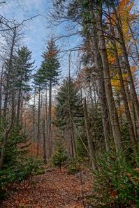
The forest on this southeast aspect of the mountain is composed mostly of mixed hardwoods (maples, oaks, and others). Formerly, it was filled with small to medium eastern hemlock, creating a dark, cool environment. A few larger ones had even managed to poke out of the canopy.
These are now all dead, and the forest is now much brighter. You can also now see that more than a handful of red spruce had been growing alongside the hemlocks. Now that they're no longer competing for sunlight with their coniferous cousins, the red spruce are starting to take off in their growth rate. These will likely be a much more conspicuous component of the forest at these mid elevations in future years.
The trail swings around the end of the ridge and comes out on top of it, and even descends a small bit. The forest at this elevation was formerly a mix of red spruce and hemlock. All but two of the mature hemlock were dead as of fall 2016. Somehow, these individuals have managed to survive and remain quite green up top. A fair bit of rhododendron mix in to the understory as well.
Passing through a shallow saddle, the trail slips off the southwest side of the ridge around a knob and continues ascending on a pleasant grade. It gets rockier at this point, but remains in good condition. There is a trail-side spring - it's fairly reliable but slows to a mere seep in dry weather. The trail then goes through one more pair of switchbacks, passing a couple of enormous trees on the way. The understory shrubs give way to an open, grassy area near the top of the ridge.
The trail continues ascending gently along the ridge and passes the 5000 ft contour along this stretch. It enters a forest dominated by red spruce; some of them are huge. After passing through a patch of dead trees and passing an old collapsed shelter or cabin of some kind, you'll reach the Blue Ridge Parkway at the 355 mile post and sign for Mount Mitchell State Park's road for an anti-climactic end to this beautiful trail.
Although several primitive campsites are in the area, there isn't much in the way of water along the ridge except for the aforementioned spring.
Since ending the hike on a road shoulder is kind of a let-down, you can give the hike some more length and a better ending by turning left and walking along the Blue Ridge Parkway for 0.2 mi to the trail for Blue Ridge Pinnacle. It's another 0.6 to the top of the Pinnacle, so making its summit your destination would add about 2 miles and 500 ft climb to the hike overall. That's well worth it.
This trail is located in the Black Mountains & Toe River area. For a list of all the trails in that area, see the Black Mountains & Toe River trails list page.
This trail also crosses into these trailhead areas:
All Photos from the Trail


GPS Map
Map Information
Download GPS Data
Click on a route, trail, or point on the map and select the GPS Data tab to download its data.
Data Formats
KML (Google Earth)
KML is the main file type used by Google Earth. If you have Google Earth installed, clicking the KML link should open the trail or point directly in Google Earth for viewing. This is the native file format used by Google Earth, but many other map applications can use and understand KML as well, so if you're not sure which one to download, KML is a good bet.
GPX
The GPX format stands for GPS Exchange - a free, open, XML format for exchanging GPS and map data. GPX is compatible with Google Earth, many other mapping programs, and most GPS devices (such as Garmin). Load the file directly into your GPS to help find your way on your next trip!
GeoJSON
GeoJSON is a newer, lightweight data exchange format which can be used to quickly share map data and may have a smaller size than KML or GPX. Many professional mapping and GIS applications support the GeoJSON format.
About the Map
Copyright
Base Layers
Base layers provided by OpenStreetMap, the US Geological Survey, the US Forest Service, and NC OneMap. Base layer images are subject to the respective copyright policies of their owners. Base layers may not be available at all times due to system maintenance or outages.
WNCOutdoors Base Layer
The WNCOutdoors Base layer is provided by WNCOutdoors.info. It is licensed by Creative Commons Attribution 3.0.
Trail and Marker Overlays
Trail layers and downloadable data are all original works created by WNCOutdoors with guidance from a variety of sources, including ensembles of our own GPS tracks, user contributed GPS tracks, official maps and GIS data from government agencies, and field observations. WNCOutdoors data is made freely available under the Open Database License - you are free to copy and use it for any purpose under the terms of that license (summary).
Tips
- Hover over a trail to see it highlighted. Helps to see start and end points for an individual trail.
- Scroll and zoom the map before printing, and that view will persist into the printed image.
- Click a trail for more details and to download it individually.
Feedback
Ratings
Average Rating: 5.0 (rated 2 times)
Rate It Now:

No comments yet.